Wedgefield, Florida  ·  A Local History

Before the Horses,
It Was Called Rocket City


In the early 1960s a developer drew a whole city into the palmetto east of Orlando — a town for the men building the moon rockets. The town never really came. What stayed behind was the room it had been drawn on.

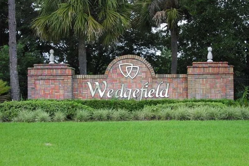
A low brick-and-stucco monument sign reading WEDGEFIELD at a neighborhood entrance, with manicured plantings and tall pines behind it under a blue sky.
The old Rocket City, today (now)
The entrance sign to Wedgefield, east Orange County — the quiet golf-and-horse community that was first drawn up, in the early 1960s, as a space-age boomtown. Photograph: Orange County Government.

Drive east out of Orlando, past the airport and out toward Bithlo, and the houses start to spread apart. The lots stretch to an acre, then past it. A horse stands behind a long wood fence. It’s about as close to open country as you can get and still have an Orlando address — and it was drawn up, once, to be a city for the men who would land on the moon.

The place is called Wedgefield now: a golf course, a country club, a few thousand people on big quiet lots. But the first name on the paperwork, back in the early 1960s, was Rocket City.

That isn’t a cute nickname somebody coined later. It was the pitch, and it was the plan.

The year someone drew a city for the moon

In the early 1960s the coast twenty-odd miles east of here was the most exciting place in America. Cape Canaveral was throwing the biggest machines anyone had ever built straight up off the ground, and Kennedy Space Center was hiring engineers and technicians by the thousand.

A tall Saturn rocket lifting off a coastal launch pad on a thick column of smoke and flame, gantry towers beside it.
Cape Canaveral, 1961
The first Saturn rocket launch, Cape Canaveral, October 27, 1961 — the kind of sight, twenty miles east, that made a city in the palmetto sound inevitable. NASA, via Wikimedia Commons.

So a developer looked at a wide, empty stretch of pine and palmetto east of Orlando and did the natural thing for Florida: he drew a city on it. Roughly twenty thousand acres of it — not a subdivision, a city — a planned town to house the people who were about to put Americans into space. On the maps it was Rocket City. Sometimes Cape Orlando.

And the pitch nearly sold itself. Serious people believed Florida’s midsection was the future. In November 1963, President Kennedy himself stood at the Cape while Wernher von Braun walked him down the length of a Saturn rocket — days before Dallas. The whole country was leaning in.

President John F. Kennedy and a group of men in suits standing outdoors at Cape Canaveral while Wernher von Braun gestures toward a rocket, pointing something out.
The Cape, November 1963
President Kennedy at Cape Canaveral, November 16, 1963, as von Braun explains the Saturn launch system. The space coast was the biggest promise in the country — and Rocket City was the bet that people would live beside it. NASA, via Wikimedia Commons.

Florida had sold the horizon before

Here’s the thing, though. Florida had run this exact play once already, a generation earlier.

A weathered 1920s roadside billboard advertising subdivision real estate lots for sale, with hand-lettered promises and prices.
Selling Florida, 1922
A billboard selling subdivision lots, Florida, December 1922 — a few years before the great 1920s land boom peaked. The space-age version followed the same script forty years on. Via Wikimedia Commons (World Digital Library).

In the 1920s, developers drained swamp, cut roads into the scrub, and sold lots to people up north who had never set foot on the ground they were buying. Sometimes there was a real city at the end of it. Often there was a grid of empty streets and a lot of palmetto.

Rocket City was that same move in a jet-age suit: cut the roads first, name the streets, print the map, and let the boom pour in behind it. For a little while, it did.

What the map was actually drawn on

Because here is what was really out there, under all that promise. Palmetto. Flat, low country — saw palmetto and wiregrass and slash pine, wet in the summer, the kind of ground that stands in water when it rains and bakes hard when it doesn’t.

Dense low saw-palmetto fronds and wildflowers under scattered pines in a sunny Florida flatwoods.
What the map was drawn on
Saw palmetto and pine flatwoods — the low, flat ground that covers this part of Florida, shown here at a state park on the coast. Representative of the scrub a buyer actually got. Photograph by Bob Peterson, via Wikimedia Commons.

Beautiful in its own flat way — big sky, open prairie running off toward the St. Johns River — but a long way from a rocket, and a long way from a grocery store. A lovely place to be if you wanted room. A hard place to sell as a bedroom suburb.

A wide, flat expanse of open Florida dry prairie, grass and low brush stretching to a distant line of trees under a huge pale sky.
Big sky, not much else
Open Florida dry prairie — the flat, treeless central-Florida landscape, shown here at Kissimmee Prairie Preserve. The interior east of Orlando looked much like this before the roads went in. U.S. Forest Service, via Wikimedia Commons.

The boom that lasted about two years

For a couple of years it worked anyway. Roads went in. Lots sold. The map filled up with promise. And then it came apart.

The boom went bust. The launches stayed on the coast — but the rocket workers mostly didn’t want to live out here in the palmetto, and the town that had been drawn for twenty thousand acres never filled in behind the roads. The developer didn’t last, and the land changed hands more than once.

A new owner would try a new name, hang a new promise on it, and watch it not quite catch. In the 1970s the billionaire John D. MacArthur took his own swing at reviving the place as Cape Orlando. That didn’t hold either. Finally, in 1983, yet another owner renamed it one last time — Wedgefield — put a golf course on it, and let the place become whatever it was going to be.

The city for the moon never really arrived. What stayed behind was the room it had been drawn on.

What was left was room

The roads were already cut. The lots were already surveyed — and surveyed big. So Wedgefield filled in the way empty things in Florida fill in: slowly, one house at a time, each sitting on an acre or more, with a lot of air between them.

Nobody ended up shoulder to shoulder. People got space instead — a pasture, a barn, a workshop out back, somewhere to keep a couple of horses. The failed rocket suburb quietly turned into horse country, and the street names that survived lean more toward the paddock than the launch pad.

Cattle standing in and along a shallow blackwater river lined with cabbage palms and live oaks.
Still cow country (now)
Cattle along the Econlockhatchee River, east of Orlando — the blackwater river and pasture country that wraps around Wedgefield. Photograph via Wikimedia Commons.

The part that never got built

And here is the real twist. The piece of the dream that failed hardest — all that land meant to become dense city that never got a single house — is right next door, and it’s the best part.

Thousands of those acres became the Hal Scott preserve: longleaf-pine savanna and the Econlockhatchee River bending through it, cattle standing in the shallows, no rooftops at all. The emptiness that was supposed to be the failure turned out to be the thing people now drive out here to find.

A calm blackwater river curving between banks of cabbage palms, ferns, and moss-draped trees, seen from a trail bridge.
The part that never got built (now)
The Econlockhatchee River from the Florida Trail bridge — the wild, un-built country that borders Wedgefield, much of it protected in the Hal Scott preserve. Photograph via Wikimedia Commons.

So the next time someone tells you Wedgefield is just a golf community with roomy yards, you can tell them the truth: it was drawn up to be a city for astronauts. And the one promise the rocket dream actually kept — the only one — was the space between one house and the next.

A present-day note · Orange Tiny Homes

That space between the houses is the whole point.

Wedgefield got its room by accident — a city drawn too big, for people who never came. But that room out back is the thing a lot of Central Florida is quietly rediscovering it already has: a single lot that can hold more than one home’s worth of living.

Today that second building out back has a name — an ADU, an accessory dwelling unit — and it’s what we build. A granny flat so a parent can live close but separate. A guest house. A rental out back that helps carry the mortgage. A tiny home on the far corner of the lot. The same idea the big Wedgefield lots make obvious, with a kitchen and a bathroom and a permit.

And you don’t need a Wedgefield-sized acre for it. Across greater Orlando and Orange County — the big east-side lots out toward Bithlo and Wedgefield, sure, but also ordinary yards in Conway, Azalea Park, Winter Garden, and Pine Hills — a lot of homes already have the room. What actually decides it is specific to your address:

The real answer to “is there room out back for this?” isn’t a guess — it’s a handful of facts about your lot. That part we can check for you.

Put in your address and we’ll pull what your parcel allows and tell you whether a granny flat, guest house, rental, or tiny home actually fits — before you spend a dollar on drawings.

Start the ADU Fit Check→
Sources & Photo Credits

On the history

Photographs & documents

  1. Wedgefield community entrance sign — present-day photograph; Orange County Government Newsroom (April 2021 article on Wedgefield). File: wedgefield-community-sign-2021. newsroom.ocfl.net
  2. First Saturn (SA-1) launch, Cape Canaveral — October 27, 1961; NASA; public domain, via Wikimedia Commons. File: saturn-sa1-launch-1961. Commons
  3. President Kennedy and Wernher von Braun at Cape Canaveral — November 16, 1963; NASA (Deputy Administrator Robert Seamans also present); public domain, via Wikimedia Commons. File: kennedy-von-braun-cape-canaveral-1963. Commons
  4. Billboard for the sale of subdivision real-estate lots — Florida, December 1922, a few years before the 1920s land boom peaked; public domain, via Wikimedia Commons (World Digital Library, item 4030). Used to represent Florida’s earlier land-sale era, not the 1960s development. File: florida-land-boom-billboard-1922. Commons
  5. Saw palmetto and pine flatwoods — Jonathan Dickinson State Park, Martin County, Florida, October 2010; photographer Bob Peterson; CC BY-SA, via Wikimedia Commons. Representative of Florida flatwoods, not a Wedgefield location. File: saw-palmetto-pine-flatwoods. Commons
  6. Open Florida dry prairie — Kissimmee Prairie Preserve State Park, 2015; U.S. Forest Service – Southern Region; public domain, via Wikimedia Commons. Representative of the flat central-Florida interior. File: florida-dry-prairie-kissimmee. Commons
  7. Cattle along the Econlockhatchee River — present-day photograph, 2015; photographer “Trougnouf” (Benoît Brummer); CC BY, via Wikimedia Commons. File: cattle-econlockhatchee-river. Commons
  8. The Econlockhatchee River from the Florida Trail bridge — present-day photograph, 2013; photographer “Trougnouf” (Benoît Brummer); CC BY-SA, via Wikimedia Commons. File: econlockhatchee-river-florida-trail. Commons

Original downloads and a full research record are kept alongside this page in assets/images/originals/ and source-record.md. Present-day photographs are labeled (now); representative landscape photographs are identified as such in their captions. No historical image was altered in any way that changes its content; the Polaroid frames and handwritten notes are CSS added around the photographs, never onto them.