Waterstone on Lake Butler · Windermere, Orlando, Florida  ·  A Local History

The Lake Named for the Man Who Drew the Lines


Lake Butler is the biggest of thirteen clear lakes west of Orlando, ringed now by gates you don’t drive through unless someone’s expecting you. It carries the name of a man who ran East Florida for exactly two days — then spent years turning the whole wild territory into squares you could buy. His lines still run under every backyard out here.

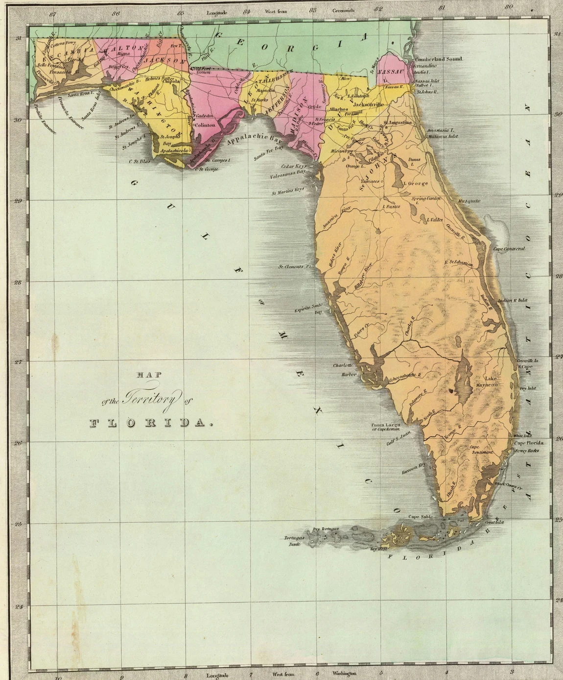
An 1834 hand-colored map of the whole Florida peninsula, a few counties blocked out in pink, yellow and green across the top, faint survey grid lines ruled over the mostly blank interior, and the title Map of the Territory of Florida lettered in the Gulf.
Florida, 1834 — all of it, almost none of it measured yet
The job, on paper. “Map of the Territory of Florida,” 1834 — a couple of settled counties across the top, faint grid lines ruled over the rest, and a whole peninsula still waiting to be turned into property. David H. Burr; via the David Rumsey Map Collection / Wikimedia Commons.

There’s a chain of lakes west of Orlando so clear that the state, in 1985, made it the first water in Florida it ever labeled “Outstanding.” Thirteen lakes, strung together, and the biggest link in the chain is Lake Butler. Gated neighborhoods sit on it now — Waterstone is one of the newest, built along the shore in the 2010s and sold as about the last place anyone could carve a brand-new street onto the lake.

But the name on the water is older than any gate, and it belongs to a man who never lived here. He didn’t fish it. He didn’t farm it. He didn’t build a thing on it. He measured it — or rather, he ran the office that did. So who was Butler, and why does a lake he may never have laid eyes on still carry his name?

Two days as governor

Robert Butler was born in 1786. When his father died, Butler and his brothers and sisters became wards of a family friend who later got a bigger job — Andrew Jackson. Butler grew up close to him, and when the shooting started he was there for it: he served at the Battle of New Orleans as Jackson’s adjutant, the officer who carries the general’s orders and makes sure they happen.

So when Spain finally handed Florida to the United States in the summer of 1821, Jackson sent a man he trusted. On the 10th of July, at St. Augustine, it was Robert Butler who formally took East Florida off the hands of the departing Spanish governor, José Coppinger. They made Butler the acting governor of East Florida that same day. He held the job two days — until the official sent to actually run it arrived. Which raises the obvious question for a man like that: then what do you do with him?

The marker in the ground

Jackson got him the job that actually mattered. Butler was named the first Surveyor General of the Territory of Florida — put in charge of turning a couple hundred miles of pine, palmetto and swamp into something a person could buy a piece of. And you can’t sell land nobody has measured. A deed has to say exactly where a thing starts and stops, or it’s just a story about dirt.

So in 1824, Butler’s people drove a marker into the ground at Tallahassee. One point. From that single stake, the entire territory would be measured — north and south along one line, east and west along another.

Pick any backyard in Florida — yours, or the lot under Waterstone’s front gate — and its legal description still counts out loud from that one marker in Tallahassee: so many miles north, so many miles west. Two hundred years on, every property line in the state is a set of directions back to a dot Robert Butler put in the dirt.Why the surveyor’s name matters

The system he was running wasn’t his invention — it was the grid the young country used on all its new land. Squares six miles on a side. Each square chopped into thirty-six smaller squares a mile across. Each of those quartered down again, and again, until you reached a piece the size a family could actually work. On paper it reads like arithmetic. On the ground it was the thing that let a person walk into unmarked woods and walk back out owning a corner of it.

An 1852 government survey plat of a single township, the land ruled into numbered sections and odd-shaped claims, each one hand-lettered with a landowner's name, beside a long ledger column listing claimants and acreages.
A township, surveyed — every square gets a name
The whole machine, on one sheet. A government land-survey plat from 1852 — the ground drawn into numbered sections, a name written across each claim, and a ledger down the side counting every owner and his acres. This one’s from Louisiana, but it’s exactly the kind of plat Florida’s surveyor-general office produced. U.S. Bureau of Land Management; via Wikimedia Commons.

That’s the entire engine of how Florida got settled, right there on one sheet. Butler’s crews cut the lines and drove the corner posts. Everybody who came after filled in the squares.

The country they filled

And the country out this way was made for spreading out. Before the oranges, before the gates, it was open range — scrub cattle and the lean, sun-cured men who worked them on horseback, pushing herds across land nobody had bothered to fence because nobody yet owned it in a way that stuck.

An 1895 pen-and-ink drawing of a Florida open-range cow hunter on horseback, slouch hat, a long stock whip coiled at his side, scrubby flatwoods behind him.
Open range, before the fences — 1895
The land before the lines. “A Cracker Cowboy,” Frederic Remington, 1895 — a Florida open-range cattle hunter. A drawing, not a photograph, published in Harper’s. Via Wikimedia Commons.

When a family did claim a square, they started small and added on. A log house first, maybe a chimney built of mud and sticks. Then a barn when there were animals to shelter, a shed when there was more to store, another room when another child came. Nobody finished a Florida homestead in a single season. You got the room first and grew into it — a habit so basic to this place it never really went away.

An 1886 photograph of a Florida log house with a tall chimney built of mud and sticks leaning against one gable end, a few people standing in the sandy dooryard.
You built small and added on
What went on a claimed square. A Florida log house with a mud-and-stick chimney, 1886 — the kind of first building a homestead family put up before anything else. Photographed by George Barker; Library of Congress. One frame of a stereograph, cropped.

Then the oranges came, and they changed what lakefront was worth. Grove land ran right down to the water on these lakes — not for the view, but because the big water did something no amount of money could. It soaked up the day’s heat and gave it back overnight, keeping the trees along the shore a few degrees warmer when a cold snap rolled down the peninsula. In citrus country, a few degrees was the difference between a crop and a wipeout. Growers paid for shoreline for that reason alone.

An elevated view around 1900 across rows of orange trees running down to a lake near Orlando, a tall packing shed among the trees and more groves stretching to the horizon.
Groves down to the water, near Orlando — about 1900
Why the shoreline was worth it. Orange groves running down to a lake near Orlando, around 1900 — water on one side held the overnight warmth that kept the trees from freezing. Detroit Publishing Co.; Library of Congress. A representative Central Florida grove-on-the-water of the era.

On these exact lakes — the Butler Chain — the work got done by hand, one tree and one ladder at a time. A grove was only ever worth what the crews could pull off the branches before it spoiled.

Three grove workers standing among orange trees with picking pails and a crate, photographed at a Windermere-area grove in 1904.
Isleworth grove, on the chain — 1904
The hands on the actual lakes. Grove workers at Isleworth, on the Butler Chain at Windermere, 1904. Chase & Co. Collection; University of Central Florida (RICHES) / University of Florida. Cropped from its card mount.

The town that kept its room

For a long stretch, the way into this country wasn’t a road. It was the water — small steamers working the lakes and rivers, a boat landing where a driveway would someday be.

An 1886 photograph of a small wood-burning stern-wheel steamer named Okeehumkee tied up at a Central Florida landing, passengers on its decks.
You arrived by water — 1886
The road was the lake. The small Central Florida steamer “Okeehumkee” at a landing, 1886 — for years the practical way to reach lake country like this. Library of Congress / World Digital Library. A representative Central Florida steamer of the era.

Then in 1887 an Englishman named John Dawe walked the narrow neck of land between Lake Butler and Lake Down, decided it was worth having, platted a village on it, and named the place after the prettiest lake he knew back home — Windermere, in England’s Lake District. The town grew slowly. A one-room schoolhouse went up in 1890, and it’s still standing. Windermere finally incorporated in 1925, and then it did a thing almost no growing Florida town has managed: it decided not to change much.

The small white wood-frame 1890 Windermere schoolhouse, now called the Parramore House, standing under oak trees, photographed in recent years.
The 1890 schoolhouse, still here
The town’s first public building. The 1890 Windermere schoolhouse — now the Parramore House — still standing in town. Photograph by Wikimedia Commons contributor Ebyabe, used under a Creative Commons license. A modern image.

Drive the old core of Windermere today and the streets are still dirt — packed sand and clay, no curb, no sidewalk. And that’s on purpose. The town spends real money to keep them unpaved: partly to slow traffic down to a crawl, partly because loose sand lets a rainstorm soak straight in instead of sheeting off dirty into those “Outstanding” lakes. A town sitting on some of the priciest shoreline in Central Florida, choosing not to pave its own Main Street to protect the water. That’s the room instinct again, hardened into a rule: hold onto the thing that makes the place the place.

What never moved

By 1890 the squares Butler’s office had drawn were filling with names. Here’s the county map from that year — it’s nothing but his grid of townships and sections with the owners written right onto their parcels.

An 1890 map of Orange County, Florida: a grid of square townships and sections, a cluster of lakes down the western side, and the surnames of landowners printed across their parcels.
Orange County, 1890 — the grid, filled with names
Room, claimed. Orange County in 1890 — townships and sections, the chain of lakes down the west side, and whoever had claimed each square printed right on it. The grid is the survey; the names are everybody who filled it. J. O. Fries & E. W. Smith & Co.; Library of Congress.

The groves are mostly lawns now. The open range is gated. The steamers are long gone, and the boat landings are docks behind somebody’s house. But the lines never moved — every one of those fences and lot corners still traces back to Butler’s grid. And the water is exactly where it always was, still clear, still the whole reason anyone wanted this ground to begin with.

A present-day view of a calm Butler Chain lake at Windermere, tall palms and shade trees along a grassy shoreline under an open sky.
The Butler Chain today, Windermere
The thing that never moved. A Butler Chain lake at Windermere today — the clear water that made this ground worth measuring, settling, and fighting to keep. Present-day photograph; via Wikimedia Commons.

A man ran Florida for two days, drew the squares the whole state still lives inside, and ended up with a chain of lakes named for him that he may never have seen with his own eyes. The gates out here came and went on their own schedule. But every property line, every lot corner, every quiet argument about where one yard ends and the next begins is still answering a question Robert Butler started asking with a chain and a compass two hundred years ago. The room was always the point. Somebody just had to draw it first.

A present-day note · Orange Tiny Homes

The room was always the point.

Strip the gates off of Lake Butler and what’s underneath is the oldest Central-Florida habit there is: get a square of ground with room on it, and put the thing you need out there yourself. The homesteaders on that 1890 map did it a barn and a back room at a time. The grove families did it with sheds and packing houses. Nobody finished their place in a season — they added on as life asked them to, because the room was sitting right there to add onto.

That instinct still pays, and the thing people build out back now has a name — an ADU, an accessory dwelling unit. That’s what we do. A granny flat so a parent can live close with their own front door. A guest house. A rental out back that helps carry the mortgage. A tiny home in the far corner of the lot. Same move the first settlers made — put what you want on the room you’ve got — just with a kitchen, a bathroom, and a permit.

And you don’t need a lot on the Butler Chain to do it. All across the greater Orlando area — the roomier lots out toward Windermere and Gotha, sure, but plenty of ordinary yards in Conway, Pine Hills, Azalea Park and unincorporated Orange County too — the space is already there. What actually decides it comes down to your own address:

The real answer to “is there room out back for this?” isn’t a guess — it’s a handful of facts about your lot. That part we can check for you.

Put in your address and we’ll pull what your parcel allows and tell you whether a granny flat, guest house, rental, or tiny home actually fits — before you spend a dollar on drawings.

Start the ADU Fit Check→
Sources & Photo Credits

On the history

On the name, honestly: there are two Lake Butlers in Florida. The city of Lake Butler, up in Union County, is documented as named for Robert Butler. For the Orange County Butler Chain of Lakes near Windermere, the name is consistently attributed to the same man — the surveyor general whose office named a number of Florida places in his honor — in local and public-history accounts, but the attribution rests on those secondary sources rather than a single primary naming record, and institutional pages (the USF Water Atlas, Wikipedia’s entry on the Orange County lake) state the name without pinning its origin. This page treats Butler the surveyor as the lake’s namesake because that is the accepted local account and it fits the documented record of his work, while flagging here that the paper trail for this particular chain is thinner than the man’s own biography. The 1824 Tallahassee-meridian facts and Butler’s biography are firmly sourced; the exact moment someone fixed “Butler” to these lakes is not. Full notes are in source-record.md beside this page.

Photographs & documents

  1. Map of the Territory of Florida, 1834 (hero) — a hand-colored map of Florida showing the early counties and faint survey grid, by David H. Burr, engraved by Illman & Pilbrow, New York, 1834. Via the David Rumsey Map Collection / Wikimedia Commons. Cropped to the map neatline. File: florida-territory-map-1834. commons.wikimedia.org
  2. Government township survey plat, 1852 — an official U.S. land-survey plat of Township 7 South, Range 4 East, Louisiana, 1852: the land ruled into numbered sections and claims, each lettered with an owner’s name, with a claimants’ ledger alongside. U.S. Bureau of Land Management; via Wikimedia Commons. Used as a representative example of the plats Florida’s surveyor-general office produced, not a Florida plat. File: glo-township-survey-plat-1852. commons.wikimedia.org
  3. “A Cracker Cowboy,” 1895 — a pen-and-ink drawing of a Florida open-range cattle hunter by Frederic Remington, published in Harper’s New Monthly Magazine, 1895. Via Wikimedia Commons. An illustration, not a photograph. File: cracker-cowboy-remington-1895. commons.wikimedia.org
  4. Florida log house with mud chimney, 1886 — a Florida “cracker” log house with a mud-and-stick chimney, people in the yard, photographed by George Barker, 1886. Library of Congress Prints & Photographs Division. One frame of a stereograph, cropped. File: florida-cracker-house-1886. loc.gov/item/2017652728
  5. Orange groves down to a lake near Orlando, c.1900 — an elevated view of orange groves running to a lake, Orlando, Florida, circa 1900. Detroit Publishing Co., Library of Congress Prints & Photographs Division. A representative Central Florida grove-on-the-water of the era. File: grove-on-the-water-orlando-c1900. loc.gov/item/2016809289
  6. Grove workers at Isleworth, Windermere, 1904 — three grove workers with picking pails at Isleworth, on the Butler Chain at Windermere, 1904. Chase & Co. Collection; University of Central Florida (RICHES) / University of Florida. Cropped from its card mount. File: isleworth-grove-workers-1904. richesmi.cah.ucf.edu
  7. Steamer “Okeehumkee,” 1886 — a small wood-burning Central Florida steamer at a landing, 1886. Library of Congress / World Digital Library. A representative Central Florida steamer of the era. File: florida-lake-steamer-1886. loc.gov/item/2021669929
  8. 1890 Windermere schoolhouse (Parramore House) — the 1890 Windermere schoolhouse, now the Parramore House, still standing in town; present-day photograph by Wikimedia Commons contributor Ebyabe, Creative Commons BY-SA. A modern image. File: windermere-1890-schoolhouse. commons.wikimedia.org
  9. Map of Orange County, Florida, 1890 — townships, sections, lakes, and landowners’ names, by J. O. Fries, published by E. W. Smith & Co., Philadelphia, 1890. Library of Congress Geography & Map Division, via Wikimedia Commons. File: orange-county-map-1890. loc.gov/item/2012592407
  10. The Butler Chain today — a present-day photograph of a Butler Chain lake at Windermere (Lake Down Park). Via Wikimedia Commons. Clearly a modern image. File: butler-chain-lake-today. commons.wikimedia.org

Original downloads and the full research record are kept alongside this page in assets/images/originals/ and source-record.md. The two survey maps (1834 Florida, 1852 township plat) are genuine period documents; the 1852 plat is a Louisiana example standing in for the identical kind of plat Florida’s surveyor-general office produced, and is labeled that way above. Several photographs are of the right era and region and are labeled as specific to their subject or as representative. No historical image was altered in a way that changes its content — the 1834 map was cropped to its neatline and downscaled, the stereograph and the plat were cropped at the edges, and the Polaroid and document frames with handwritten notes are CSS added around the images, never painted onto them.