Lake Hart, Florida  ·  A Local History

The Cattle Corner That Had Room for a Whole Headquarters


Twenty miles southeast of downtown Orlando, the land around Lake Hart stayed open range and grove so long that when one of the largest Christian organizations on earth went looking for a place big enough to build its entire world headquarters, this empty corner is where it landed.

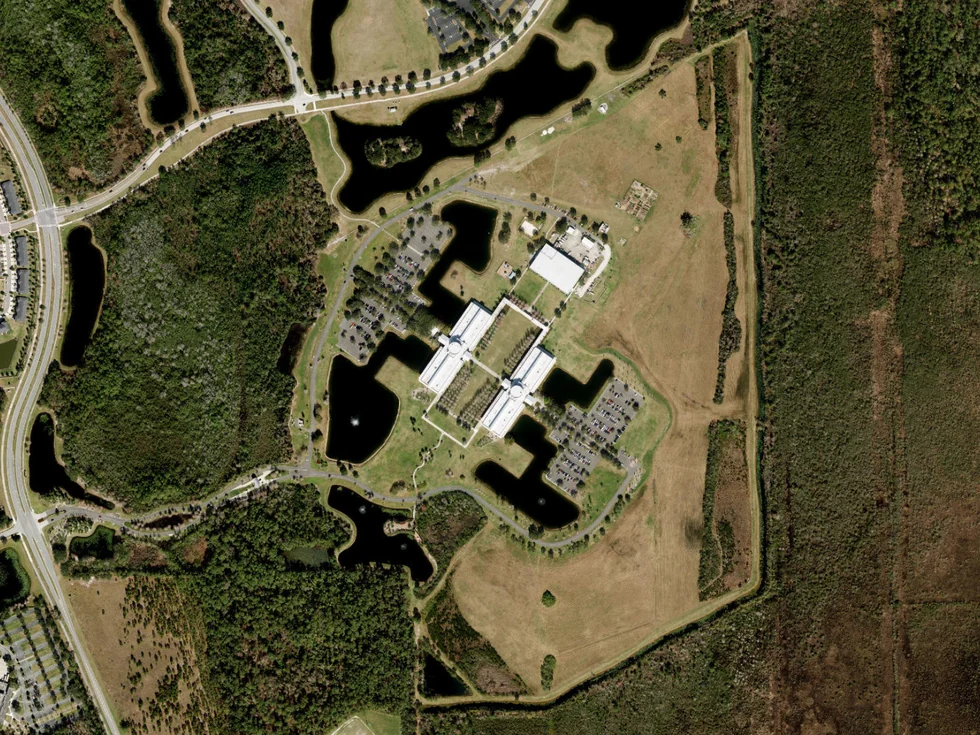
A satellite view of a large institutional campus — a cluster of big buildings, parking lots, and retention ponds — surrounded on every side by open green land, fields, and tree lines.
100 Lake Hart Drive — the room, used up
A world headquarters, out on the old pasture. The Cru (Campus Crusade for Christ) world headquarters on Lake Hart Drive, southeast of Orlando, seen from above. Satellite imagery: Esri World Imagery.

Drive southeast out of Orlando — past the airport, past the last of the new subdivisions — and the land starts to open back up into something close to what it looked like a century ago: flat, green, more water than road. Then, out in the middle of it, a campus. Not a strip mall, not a warehouse. The world headquarters of one of the largest Christian organizations on the planet, sitting on a few hundred acres that were cattle pasture within living memory. The address is 100 Lake Hart Drive. Standing there, the obvious question is: why here?

The short answer is the same one this corner of Orange County has been giving for a hundred and fifty years. There was room.

The far edge of everything

Lake Hart sits about twenty miles southeast of downtown Orlando, out where Orange County runs down to the Osceola line. For most of its history that distance was the whole point of the place — it was far. Too far out to be worth much, which is exactly what kept it open.

A worn black-and-white photograph of cattle standing in the shallow edge of a lake, with flat open pine woods along the far shore.
Open range — Lake Hart country
The cattle got there first. Florida cattle on the open range, around 1910 — the look of this country before fences. State Archives of Florida, Florida Memory. A representative open-range scene, not Lake Hart itself.

This was open-range cattle country. Before Florida fenced its herds, cattle wandered loose across the flatwoods, and men on marsh ponies — “cow hunters” — rode out to gather them from the palmetto and the lake edges. On the higher, drier ground, people set out citrus. Between the two, the land stayed mostly as it had always been: pine, palmetto, scrub, and a lot of shallow water.

Who was Hart?

Nobody wrote down for certain who Lake Hart was named for — a lot of these Central Florida lake names lost their stories a long time ago. But the oldest good map of the county, drawn from actual surveys in 1890, leaves a clue.

A detail of an 1890 hand-colored survey map showing three lakes labeled Lake Barton, Lake Hart, and Lake Fries, set among a grid of numbered sections, marsh shading, and a few scattered homestead marks.
Lake Hart, 1890 — and “E. Hart” up the road
The name was already on the water. Lake Hart, with little Lake Barton to its northwest (today’s Lake Whippoorwill) and Lake Fries to the east (today’s Lake Mary Jane). Just north of the shore, the surveyor marked a single homestead lettered “E. Hart.” Detail from “Map of Orange County, Florida, from Actual Surveys,” J. O. Fries, County Surveyor, 1890; Library of Congress.

On it, the lake is already labeled Lake Hart, with little Lake Barton tucked against its northwest side — you’ll find that one on today’s maps as Lake Whippoorwill — and Lake Fries to the east, the lake we now call Lake Mary Jane. And just up the road from the north shore, the surveyor inked a single homestead: a small black square, lettered E. Hart. The record doesn’t say more than that. But there’s the name, sitting right where the lake got it.

You built what you needed

Out here, having room wasn’t scenery. It was the whole way of living. When your nearest neighbor was a half-mile off and the nearest town was most of a day away by wagon, you didn’t run into town for things. You built them.

A weathered wooden Florida farmhouse and a smaller outbuilding under tall trees, with a split-rail fence, a garden plot, and an open yard around them.
A second place out back
Room was for building on. A Florida farmstead — main house, a detached kitchen, outbuildings — the way families used their ground out here. Dudley Farm, a preserved 1880s–1920s homestead in Alachua County. Photograph 2014. A representative Florida farmstead, not Lake Hart itself.

A main house. A detached kitchen set a little apart, so the cookstove wouldn’t take the house with it on a hot July afternoon. A barn, a smokehouse. And often a second little dwelling out back — for the grown kids, for aging parents, for the hand who helped work the grove. The habit was simple: when you’ve got ground, you put the next useful thing on it. Hold onto that one; it comes back at the end.

A mountain resort trades places with a cow pasture

Campus Crusade for Christ was founded in 1951 by Bill and Vonette Bright, on the campus at UCLA. For three decades its headquarters sat about as far from Lake Hart as you could get and still be in the country: Arrowhead Springs, a grand mineral-springs resort hotel in the hills above San Bernardino, California.

A color photograph of a smiling middle-aged man in a suit and tie beside a smiling woman in a floral dress, posed together indoors.
The founders — Bill & Vonette, 1980
The couple who built the organization. Bill and Vonette Bright, who founded Campus Crusade for Christ in 1951. Photographed in 1980 (not in Florida). Via Wikimedia Commons; public domain.

By the late 1980s the organization had outgrown the mountain and gone looking for somewhere new — central to the country, cheap to build on, easy to fly in and out of. Orlando, with its airport and its miles of open, affordable land, checked every box.

What it found was 285 acres on Lake Hart — room enough to lose a small town in — out past the airport, where the price of an acre still made sense. The county helped the deal along with a promise of road money, a couple of million dollars’ worth. The move was made in 1991, and the big campus — a complex you could set down in a downtown and call a civic center — was dedicated out on the old pasture in 1999.

“We feel strongly that God led us to Orlando, and we’re glad he did,” the organization’s founder said at the time.

Whatever led them, the practical fact was the one Lake Hart had been offering all along: space to build something big, right next to good roads, without paying city prices for it. The empty corner finally got used. Its cow-pasture address became 100 Lake Hart Drive, and the organization itself, years later, shortened its name to simply Cru.

The room keeps getting spent

Once the far edge of the county turns out to be reachable, it doesn’t stay empty for long. The same open land that drew a world headquarters also drew the planned city next door.

A single cow standing in a wide, flat, open pasture under a big cloudy sky, with a road sign at the fence line and no buildings in sight.
Still pasture — 2012
A “Medical City,” a few years off. The site of Lake Nona’s Town Center, a short drive west of Lake Hart, photographed in December 2012 — still open pasture where hospitals and research campuses stand now. “Lake Nona Town Center,” East Park, 2012; Wikimedia Commons, CC BY 3.0.

As recently as 2012, the site of Lake Nona’s “Medical City” — the hospitals and research campuses a few minutes west — was still open field with cattle standing in it. You can watch a hundred years go by fast out here: cow range, then a headquarters, then a whole engineered town, all on ground that was “too far out” within a single lifetime.

What’s still here

And a lot of the old character held on, because there was enough of it to go around. Moss Park, the county park on the neck of land pressed right against Lake Hart’s shore, still looks the part — live oaks dragging Spanish moss, black water, the kind of quiet you have to drive a while to reach.

A park entrance with a low stone-and-iron gate, a bed of red flowers, a split-rail fence, and large live oaks heavy with Spanish moss along the drive.
The lake’s still here
The quiet that distance left behind. The entrance to Moss Park, on the shore of Lake Hart. Photograph 2012; “Moss Park Reserve,” East Park, Wikimedia Commons, CC BY 3.0.

Stand at the water there and you can take in the whole thing at once: the lake still carrying its pioneer’s name, a shoreline nobody ever got around to clearing, and — a couple of miles up the road — a world headquarters parked on what used to be somebody’s cattle range. Same corner, same reason it all ended up here. There was room, and out here somebody always turns up with the next use for it.

A present-day note · Orange Tiny Homes

The room out back is still the whole idea.

Strip away the headquarters and Lake Hart is a plain Central-Florida story: when you’ve got ground, you put something useful on it. A grove. A barn. A detached kitchen. A second little house out back for family, or for the hand who worked the place. The room was never decoration — it was where the next needed thing went.

That instinct still pays, and these days the thing people build out back has a name — an ADU, an accessory dwelling unit — and it’s what we build. A granny flat so a parent can live close with their own front door. A guest house. A rental out back that helps carry the mortgage. A tiny home on the far corner of the lot. The same idea those old homesteads ran on, just with a kitchen, a bathroom, and a permit.

And you don’t need 285 acres to do it. All over greater Orlando — the roomy lots out toward Lake Hart, Wedgefield and Christmas, sure, but also ordinary yards in Conway, Azalea Park, Pine Hills and Meadow Woods — plenty of homes already have the space. What actually decides it comes down to your own address:

The real answer to “is there room out back for this?” isn’t a guess — it’s a handful of facts about your lot. That part we can check for you.

Put in your address and we’ll pull what your parcel allows and tell you whether a granny flat, guest house, rental, or tiny home actually fits — before you spend a dollar on drawings.

Start the ADU Fit Check→
Sources & Photo Credits

On the history

What is specific and what is representative: of the images here, the satellite view of the Cru campus, the 1890 Fries map detail, the Lake Nona Town Center pasture, the Moss Park entrance, and the portrait of Bill and Vonette Bright are of the real subjects named. The open-range cattle photograph and the Dudley Farm farmstead are labeled in their captions as representative Florida scenes standing in for the open-range and homestead history described — Lake Hart is a small place without a deep photographic archive of its own. The Bright portrait was made in 1980 and not in Florida; it is used only to show the organization’s founders. Sources differ on the exact year the U.S. organization adopted the name “Cru” (2011 vs. 2012), so no year is stated in the text. Full notes are in source-record.md beside this page.

Photographs & map

  1. Cru world headquarters, Lake Hart (hero) — satellite view of the campus at 100 Lake Hart Drive, Orlando. Esri World Imagery, accessed 2026-10-23. The genuine site. File: cru-campus-aerial.
  2. Florida open-range cattle, c.1910 — cattle at a lake edge in open pine country; State Archives of Florida, Florida Memory (item 90031). Representative, not Lake Hart. File: florida-open-range-cattle-1910. floridamemory.com/items/show/90031
  3. Map of Orange County, Florida, 1890 (detail) — Lake Hart, Lake Barton and Lake Fries, with the “E. Hart” homestead; J. O. Fries, County Surveyor, 1890; Library of Congress. The genuine document. File: lake-hart-map-1890. loc.gov/item/2012592407
  4. Florida farmstead — farmhouse and outbuildings at Dudley Farm, a preserved 1880s–1920s homestead in Alachua County; photograph 2014. Representative Florida farmstead. File: florida-farmstead. Wikimedia Commons, CC BY-SA 4.0. commons.wikimedia.org
  5. Bill and Vonette Bright — the founders of Campus Crusade for Christ, photographed 1980 (in Finland, not Florida). Wikimedia Commons; public domain. File: bill-vonette-bright-1980. commons.wikimedia.org
  6. Lake Nona Town Center site, 2012 — open pasture where the Town Center/“Medical City” now stands, a short drive west of Lake Hart; “Lake Nona Town Center,” East Park, December 2012. The genuine site, before development. File: lake-nona-pasture-2012. Wikimedia Commons, CC BY 3.0. commons.wikimedia.org
  7. Moss Park, Lake Hart — the park entrance on Lake Hart’s shore; “Moss Park Reserve,” East Park, December 2012. The genuine place. File: moss-park-lake-hart-2012. Wikimedia Commons, CC BY 3.0. commons.wikimedia.org

Original downloads and a full research record are kept alongside this page in assets/images/originals/ and source-record.md. No historical image was altered in a way that changes its content. The Polaroid frames and handwritten notes are CSS added around the images, never onto them.